Overview
Duration :
32 Days
Secondary Activity:
Culture
Max altitude :
4950m/16335 ft
Transportation:
International and Domestic Flights, Private Vehicle
Trip ends in:
Kathmandu
Accomodation:
Hotel
Primary activity:
Trekking and Sightseeing
Group Size:
Min. 1 pax
Country:
Bhutan
Trip starts from:
Kathmandu
Diffficulty:
Strenuous
Meals:
Nepali, Cotinental and Bhutanese
Best Season:
All Seasons
Trip route:
Kathmandu - Paro Bhutan - Army Camp - Pine Camp - Thangkthanka - Jangothang - Lingshi - Chebisa - Shakshepasa - Robluthang - Limithang - Laya - Rodufu -Narethang - Tarina - Woche - Lhedi - Thanza - Danji - Tso Chena - Jichu Dramo - Chukarpo - Thampe Tso - Maurothang - Upper Sephu - Punakha - Thimphu - Paro
Trip introduction
Possibly one of the best trekking trails on Earth; Bhutan’s unfathomable Bhutan Snowman Trek takes you on a long journey through the Himalayas. It is our most difficult trek in Bhutan which goes from Paro in the west to Trongsa in the east. Initially, the trek starts with a hike to Taktsang Monastery perched on a cliff.
Throughout this incredible 32 days Bhutan Snowman trek, we will cross several high passes in an overabundance of 4500 meters; including 5 more than 5000 meters. Then visit the practically isolate mountain kingdom of Lunana, one of the remotest valleys on the planet. En route, we’ll encounter marvelous perspectives of snow-topped mountains like the Mt. Jumolhari and Mt. Jichu Drake as we travel through some famous towns of Bhutan. Not only that but also travelers will get to experience camping overnight underneath some of Bhutan’s most noteworthy mountain crests while crossing wonderful scenes from lavish valleys and thick woods to high mountain passes. This is why the Trek is gaining popularity gradually.
Contact Nepal Mountain Trekkers right now and join our 32 days Bhutan Snowman Trek to experience the enchantment of the pure and exotic land, through its ancient fortresses, monasteries, and temples that dot the countryside.
Special Note:
If this itinerary doesn’t suit your requirement or if you want to customize it, please feel free to contact us. This trek could be customized as per your required time frame and budget limits.
Overview
-
Day 1Arrive at Kathmandu:
-
Day 2Sightseeing and Trek Preparation:
-
Day 3Fly Kathmandu to Paro Bhutan by Druk Air:
-
Day 4Hike to Taktsang Monastery:
-
Day 5Army Camp to Pine Camp: Distance: 13km - 4 to 5 hours:
-
Day 6Pine Camp to Thangkthanka: Distance: 18km - 6 to 7 hours:
-
Day 7Thangthanka to Jangothang: Distance: 19km - 5 to 6 hours:
-
Day 8Rest day in Jangothang (Chomolhari Base Camp):
-
Day 9Jangothang to Lingshi: Distance: 20km - 6 to 7 hours:
-
Day 10Lingshi to Chebisa: Distance: 14km - 4 to 5 hours:
-
Day 11Chebisa to Shakshepasa: Distance: 13km - 4 hours:
-
Day 12Shakshepasa to Robluthang: Distance: 18km - 7 to 8 hours:
-
Day 13Robluthang to Limithang: Distance: 19km - 7 to 8 hours:
-
Day 14Limithang to Laya: Distance: 10km - 4 to 5 hours:
-
Day 15Rest day in Laya:
-
Day 16Laya to Rodufu: Distance: 19km - 6 to 7 hours:
-
Day 17Rodufu to Narethang: Distance: 16km - 8 to 9 hours:
-
Day 18Narethang to Tarina: Distance 18km - 6 to 7 hours:
-
Day 19Tarina to Woche: Distance: 15km - 5 to 6 hours:
-
Day 20Woche to Lhedi: Distance: 19km - 7 to 8 hours:
-
Day 21Lhedi to Thanza: Distance: 19km - 6 to 7 hours:
-
Day 22Rest Day In Thanza, 4080m (13,300 ft):
-
Day 23Thanza to Danji: Distance: 8km - 4 hours:
-
Day 24Danji to Tso Chena: Distance: 12km - 5 hours:
-
Day 25Tso Chena to Jichu Dramo: Distance: 14km - 4 to 5 hours:
-
Day 26Jichu Dramo to Chukarpo: Distance: 18km - 6 to 7 hours:
-
Day 27Chukarpo to Thampe Tso: Distance: 18km - 5 to 6 hours:
-
Day 28Thampe Tso to Maurothang: Distance: 14km - 5 hours:
-
Day 29Maurothang to Upper Sephu - Drive to Punakha: Distance: 17km - 5 hours:
-
Day 30Drive Punakha to Thimphu:
-
Day 31Drive Thimphu to Paro:
-
Day 32Depart Paro for home:
Detail Itinerary
Day 1 : Arrive at Kathmandu::
As soon as you arrive at the capital city, Kathmandu, you will be met by a representative from Nepal Mountain Trekkers at International Airport terminals and he will take you to your respective hotel (Hotel Green Horizon). After check-in at the hotel, you can enjoy your free time relaxing in a cozy room or stroll around the tourist hub Thamel area until the end of the day.
Day 2 : Sightseeing and Trek Preparation::
After having our early meal, we start our day with a visit to the Nepal Mountain Trekkers office at Thamel. After being introduced to our team including tour guide, trekking leader, and director of operations, we head for necessary trekking preparations, getting needed equipment with the initiation of Kathmandu sightseeing around world heritage sites. Kathmandu durbar square, Swayambhunath stupa, Pashupatinath temple, and Boudhanath stupa are UNESCO world heritage sites that we explore till sunset. Overnight stay at the hotel in Kathmandu. B included.
Day 3 : Fly Kathmandu to Paro Bhutan by Druk Air::
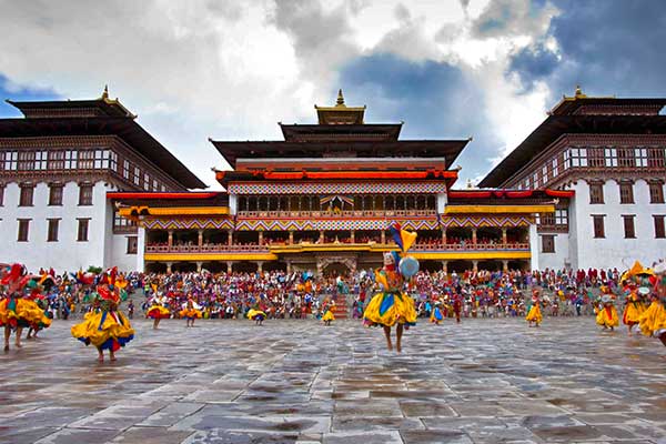
Arrive Paro by Druk Air Airbus 319 jet, the national carrier. The flight offers you beautiful views of mountains on your approach. On arrival and after visa formalities you will be received by our representatives and transferred to your very comfortable hotel. In the afternoon you will have the opportunity to explore Paro town a little and visit Paro Dzong. A Dzong is part fortress, part castle, part monastery, and part administration building. Paro Dzong is one of Bhutan’s most impressive and well-known dzongs, and the finest example of Bhutanese architecture we’ll see. The inward-sloping walls form a massive structure that towers over the town and is visible as a great white monolith from vantage points throughout the valley. Paro is at 2280 meters (7,500 ft).
Day 4 : Hike to Taktsang Monastery::
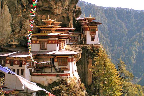
Day hike to Taktsang monastery, the famous “Tiger’s Nest”. Horses can be arranged for about $8 USD. The hike which is all uphill takes about 2-3 hours through a lovely pine forest. The monastery which clings to a huge granite cliff 800 meters above the Paro valley was devastated by fire in 1998, but the Royal Government took immediate steps to restore the monastery to its original structure, and it has been completely rebuilt. It is believed that the Buddhist saint Padmasambhava came in the 7th century on a flying tigress and meditated in a cave for 3 months. The demons were subdued who were trying to stop the spread of Buddhism and converted the Paro valley to Buddhism. During the end of the 17 century, a monastery was built on the spot where the saint meditated and it is a pilgrimage site for every Bhutanese to visit once in their lifetime. Drive back to the hotel.
Day 5 : Army Camp to Pine Camp: Distance: 13km - 4 to 5 hours::
A short drive from Paro takes us to Drukgyel Dzong, the old fort where the trek used to begin, but we continue up the extended road to the Army Camp and the start of our trekking route. Heading up the Paro Chhu river valley, the trail passes the small settlements where we see excellent examples of Bhutanese farmhouses, and then through a forest to ‘Pine Camp’ (3,000m / 9,850 feet).
Day 6 : Pine Camp to Thangkthanka: Distance: 18km - 6 to 7 hours::
Leaving Pine Camp the trail continues upriver and the route winds in and out of rhododendron and blue pine forests. We are now in Jigme Dorji National Park, so keep your eyes open for wildlife and changes in vegetation as we continue to climb in elevation. Tonight we camp in Thangkthanka (3,520m / 11,545 ft. )
Day 7 : Thangthanka to Jangothang: Distance: 19km - 5 to 6 hours::
An hour out of camp this morning we leave the tree line and head into the high mountains. At the halfway point of our hike, we cross Tengethang, a winter home of the migratory yak herders. Arriving at Jangothang (4,040m / 13,250 ft), we can watch the sunset on Mt. Jhomolhari (7,314m) and Mt. Jichu Drake (6,989m).
Day 8 : Rest day in Jangothang (Chomolhari Base Camp)::
On the first of our acclimatization days, we have many day-hiking options. The first is a three to four-hour excursion up the ridge to the north for great views of Jichu Drake. The second is to hike up towards the head of the valley in the direction of Jhomolhari. The third is a trek up the main valley towards the last house and onward toward Jichu Drake, this gives a great view of where we will be going in the next few days. The final alternative is a fishing expedition to Tshophu, a high-altitude lake about a two-hour hike away.
Day 9 : Jangothang to Lingshi: Distance: 20km - 6 to 7 hours::
Heading uphill from Jangothang we cross the first of many major passes. The Nyile La pass at 4,890m (16,135 ft) is about a four-hour ascent. Descending the other side we will encounter sparse juniper and rhododendron and pass many yak herder camps. From this area on we start to see herds of blue sheep. Arriving in Lingshi we set up camp at 4150m (13,700 ft).
Day 10 : Lingshi to Chebisa: Distance: 14km - 4 to 5 hours::
This morning we will visit Lingshi Dzong, also known as Yugyel Dzong in the 17th century, it was used in past to control travel between Tibet and Bhutan. Since today’s hike will not be as long, the pace will be more relaxed. Upon reaching the camp at Chebisa (3,850m / 12,600 ft), we will have time to visit Chebisa village and see a slice of Bhutanese village life.
Day 11 : Chebisa to Shakshepasa: Distance: 13km - 4 hours::
Crossing the Gombu La pass at 4,350m (14,300 ft), we descend into a rhododendron-filled valley and continue past some yak herder camps to Shakshepasa where we camp at 3,980m (13,100 ft). Sometimes we continue on to a bigger (flatter) camp 1.5 hours further along the trail to make the next day a little shorter.
Day 12 : Shakshepasa to Robluthang: Distance: 18km - 7 to 8 hours::
An early morning start will get us on the way to Jhari La pass at 4747m (15,600 ft). Descending to Tsharijathang, the valley where herds of Takin (the national animal of Bhutan) are normally seen. From here we climb to our camp at Robluthang at 4160m (13,700 ft).
Day 13 : Robluthang to Limithang: Distance: 19km - 7 to 8 hours::
Starting early a strenuous hike leads to the Shinge La pass at 5,005m (16,650 ft). Descending to Limithang we’ll see Mt. Gangchenta (6840m) and the glacially carved Gangchhenta valley. Gangchhenta means Great Tiger Mountain. We camp at 4,140m (13,650 ft).
Day 14 : Limithang to Laya: Distance: 10km - 4 to 5 hours::
A shorter hike follows a trail in and out of a heavily wooded, uninhabited valley. Climbing up out of the forests we will be rewarded with some great views of the Gangchhenta and Masang Gang (7,165m) mountains. We camp at Laya at 3,840m (12,650 ft).
Day 15 : Rest day in Laya::
Staying in Laya for the day we will get a chance to see the village with its community school, hospital, archery field, and the first shop since the Paro Valley. Laya is a unique village of about 800 people with their own language, customs, and distinct dress. The women keep their hair long and wear peculiar conical bamboo hats with a bamboo spike at the top. They wear a lot of silver jewelry on their backs, on many women this display includes an array of teaspoons.
Day 16 : Laya to Rodufu: Distance: 19km - 6 to 7 hours::
The trek leads gradually downhill to the Lunana trail junction, then makes a gradual climb to the camp through a forest of conifers, maple and rhododendron. The trail improves and becomes wider as we climb out of the river valley. We camp at Rodufu near a small stream at 4,160m (13,645 ft).
Day 17 : Rodufu to Narethang: Distance: 16km - 8 to 9 hours::
It is a long hike, first crossing the Tsimo La pass at 4,950m (16,200 ft). Descending to Narethang we pass some dwarf rhododendron and hike in the shadow of Gangla Karchung peak (6,395m). We camp at 4,900m (16,000 ft).
Day 18 : Narethang to Tarina: Distance 18km - 6 to 7 hours::
Climb to Karchung La pass at 5,240m (17,187 ft) and down to the glacial lakes that are the source of the Tang Chhu river. Above the lakes are the mighty peaks of Jejekangphu Gang (7,300m) and Tsenda Kang (7,100m). We camp at Tarina, 4,020m (13,250 ft).
Day 19 : Tarina to Woche: Distance: 15km - 5 to 6 hours::
The walk leads down through conifer forests, following the upper reaches of the Pho Chhu river. The trail then climbs over a ridge and drops to the village of Woche at 3940m (13,000 ft). The trek has now entered the Lunana region. We often continue on about an hour past Woche to a spectacular campsite below the Keche La pass.
Day 20 : Woche to Lhedi: Distance: 19km - 7 to 8 hours::
It’s a gradual climb from Woche to the campsite below the pass and then gets steeper on the section up to the Keche La, at 4580m (15,100 ft), after which it drops steeply to Thega village our usual lunch spot. The afternoon hike continues along a beautiful river valley past spectacular waterfalls to Lhedi village where we camp at 3,600m (11,800 ft). Sometimes we continue on about an hour or so beyond Lhedi village to a lovely campsite.
Day 21 : Lhedi to Thanza: Distance: 19km - 6 to 7 hours::
The trail climbs gradually following the main source of the Pho Chhu to Chozo village. At the small Chozo Dzong, there are some lay monks. Above Chozo, the valley opens as we approach Thanza village near the foot of 7,100m Zogophu Gamp, which is also known as Table Mountain. We camp at Thanza, 4,080m (13,300 ft).
Day 22 : Rest Day In Thanza, 4080m (13,300 ft)::
This day is a fantastic opportunity to interact with the hospitable local villagers and explore the beautiful surrounding area, our farthest point in the Lunana valley. Alternatively, you can relax around camp and rest up for some of the tough days ahead. As Thanza is sometimes a transfer point for horses and yaks, it is sometimes necessary to have a day here for our staff to ensure all the necessary yaks are rounded up by the local herders who do not operate on ‘Western time’! Please note: Assuming everyone in the trekking party has acclimatized properly up to this point, and our horse/yak logistics are smoothly in place, we may only spend the morning in Thanza, and leave for our campsite up the valley at Danji in the afternoon in order to save the rest day in case it is required later in the trek due to altitude or weather-related concerns while crossing the Rinchen Zoe pass out of Lunana.
Day 23 : Thanza to Danji: Distance: 8km - 4 hours::
Today is a relatively short, although somewhat steep, climb to a campsite called Danji, partway up to the Jaze la pass. It will allow us to have some extra time in the morning and make a later start. The camp is around 4600m/15,000ft, with spectacular views of snow-capped peaks! It is an important acclimatization spot.
Day 24 : Danji to Tso Chena: Distance: 12km - 5 hours::
The first part of the day involves a climb up over three false summits to Jaze La pass at 5,050m (16,570ft). From the pass, it is a short downhill trek to the campsite at the lake of Tso Chena at 4,800m (15,740 ft). Keep your eyes open for blue sheep during the hike.
Day 25 : Tso Chena to Jichu Dramo: Distance: 14km - 4 to 5 hours::
The trail has a series of gradual ups and downs between the snow-capped peaks and across the Loju La pass at 4,940m (16,300 ft) before descending to camp at Jichu Dramo at 4880m (16,000 ft).
Day 26 : Jichu Dramo to Chukarpo: Distance: 18km - 6 to 7 hours::
We start with a hard climb to Rinchen Zoe La pass at 5,290m (17,350 ft), the highest on the trek. It is then all downhill to Chukarpo, which is just above the tree line at 4,950m (1,6335 ft).
Day 27 : Chukarpo to Thampe Tso: Distance: 18km - 5 to 6 hours::
It is a long mostly downhill walk along the river, followed by a climb up to the Um So lake at 4,230m (13,950 ft). In this lake, Pema Lingpa found a number of religious treasures. Continuing downhill we camp by the lake of Thampe Tso at 4,200m (13,860 ft).
Day 28 : Thampe Tso to Maurothang: Distance: 14km - 5 hours::
It is a short walk to the base of Thampe La and a steep climb to the pass at 4,580m (15,100 ft). The trek is then all downhill through rhododendron bushes to the yak pasture of Maurothang where we camp at 3,550m (11,640 ft).
Day 29 : Maurothang to Upper Sephu - Drive to Punakha: Distance: 17km - 5 hours::
On our final day of trekking, we descend through a beautiful valley to the lovely village of Sephu where the new road-head beyond Nikachu Chazam continues to push up the valley to the upper part of the village. From there, if time permits, we will drive east to Trongsa. This beautiful Dzong is the center of the region of Bhutan called “Bumthang”. The Trongsa Dzong is one of the most impressive in the kingdom and can be seen from a great distance in its strategic position high above the Mangde Chhu river. In the late afternoon/early evening, we have a spectacular 3-hour drive back west across the mountains to Punakha. We stop along the way at Chendebji to visit the Chendebji Chorten, patterned after Swayambhunath in Kathmandu and built in the 19th century by Lama Shida from Tibet. We also stop at the top of the Pele La pass (3,400m). Overnight in Punakha at a very comfortable hotel.
Day 30 : Drive Punakha to Thimphu::
We will have time in the morning to see Punakha Dzong (the second of Bhutan’s dzongs to be built) which for many years served as the seat of government. The dzong was first built in 1637 and is still one of the largest in Bhutan. We will drive to Thimphu in the morning (about 2 hours) and have the afternoon to visit Thimphu, the capital of Bhutan. We will visit the Trashi Chhoe Dzong, built as the symbol of the capital, and then explore the shops along with Norzin Lam, Thimphu’s main street.
Day 31 : Drive Thimphu to Paro::
The morning is free to do some more sightseeing or shopping around Thimphu. In the afternoon we take a 2-hour drive through the lovely central foothills to Paro where we will overnight in a comfortable hotel.
Day 32 : Depart Paro for home::
Waking up in Paro, we’ll have time for one last walk through town before saying our goodbyes and heading to the airport for the Druk Air flight out of Bhutan.
Price Includes
Price Excludes
Trip Gallery
Trip Map:
Equipments
 Equipment List
- Duffel Bag
- Day Pack (35-45 L)
- Sleeping Bag (-20F/-30C recommended)
- Down Jacket
- Trekking Boots
- Crocs (evenings & washing)
- Trekking Pants (2-3)
- T-Shirts (3)
- Long-sleeve Trekking Shirts (2-3)
- Trekking Jacket
- Gortex (or similar) Jacket & Pants
- Fleece or Thermal Top (evenings)
- Fleece or Thermal Bottoms (evenings)
- Lightweight Long Underwear (to sleep in or layer under clothes)
- Socks (5)
- Gloves (lighter & heavier for passes)
- Wool Hat
- Baseball Cap or Wide-brimmed Hat
- Camp Towel
- Trekking Poles (optional, recommended)
- Down Booties (optional, recommended)
- Sunglasses (2)
- Water Bottles | Nalgenes (2-3)
- Bladder (optional, recommended)
- Toiletries, Sunscreen with SPF, Lip Balm with SPF
- Watch (with alarm)
- Extra Batteries
- Battery Chargers
- Head Lamp (2)
- Yak Trax (for treks with icy passes)
- Water Purifying Tablets, Small Water Filter or Steripen
- Camp Washing Bowl (optional, collapsible for clothes)
- Laundry Detergent (Kathmandu) or Bio-degradable Clothes Soap
- Hand Sanitizer
- Small Solar Panel (optional, recommended for iPods, iPhones, camera batteries, Kindles)
- Book(s)
- Zip-Lock | Plastic Bags
- Soft Toilet Paper | Tissues (we supply toilet paper but you will want something softer for blowing your nose)
- Baby-Wipes | Wet-Wipes (for personal cleaning)
- Handi-Wipes, J-Cloth, or Chux (optional: easy for a quick daytime clean, fast drying)
- Rehydration | Electrolytes
- Snacks!
- Personal Medical Supplies
- Snacks, chocolate bars, energy bars (Western brands), dried fruit & nuts
- Laundry Detergent
- ALL trekking gear (Sherpa Gear, Mountain Hardwear, Tsetang’s Gear Shop all have real gear), real & knock-offs.
- Lemon Tang (for water if you want)
- Batteries
- Trekking Poles
- Micro Spikes
- Medical Supplies
- We strongly suggest bringing Western meds with you as there are a lot of Indian fakes on the market!
- Suggested: Diamox, Azithromycin, Ciprofloxacin, Tinidazole, or Flagyl & Augmentin. Bring COMPEED for covering blisters & good tasting electrolytes &/or rehydration salts (Emergen-C is a good American brand). The local versions aren’t very appealing.
- We also recommend bringing strong knee & ankle supports & braces, ACE bandages for sprains & strains, Tegaderm &/or other would coverings. Duct tape is always useful. We’re happy to take excess medical supplies off your hands when you leave if you won’t need them and pass them on to others. We use lots of the large amount we have with us to treat locals we meet when trekking.
Related Trips
You will also like …
Bhutan Culture Tour
- 12 Days
- Moderate
Bhutan Festival Tour
- 2 Days
- Moderate
Bhutan Tour
- 7 Days
- Moderate
Nepal Bhutan Sikkim Darjeeling Tour
- 12 Days
- Moderate


